
Run New Mexico
Rio Grande Bosque
Enchantment abounds everywhere along the Rio Grande Bosque. There are miles and miles of uninterrupted trail gorgeousness complete with views of the Rio Grande, beautiful riparian cottonwood forest, and the historic acequia agriculture systems that are part of New Mexico’s heritage. Hot air balloons rising into the crisp early morning sky are common and you might even get to see our state bird, the roadrunner. If the day warms up, there are pleasantly shaded sections where you can quick break and take in the scenery. Elevation along the Bosque remains a fairly flat 5,000 feet the entire way making this the perfect entry point to high altitude. Whether you’re looking for a few easy and scenic miles or if you want to practice marathon pace for a long run, this is the spot.

-
Our favorite place to park is in the City of Albuquerque - Alameda Bosque Trail Lot . The access to this lot is right off of Alameda Boulevard NW. The turn is located between Rio Grande Boulevard and the Alameda Rio Grande Bridge (southeast side of the bridge). There is not an actual street address for this lot so you may want to use this Google Maps pin. Please note that you’ll run south from this location.
-
There are restroom facilities at this location. Please note they do not have running water.
-
Weekends get busy so the earlier you arrive, the better.
The adjacent County of Bernalillo - Bachechi Open Space grounds are a gorgeous place to walk around and cool down after your run.
It’s almost impossible to get lost here. All the trails from this lot are between the river and the large irrigation acequia - just take the next trail that goes opposite of the water (East) and you’ll get back to the main paved trail quickly.
-
For a cold beer and good food after, Steelbender Brewery is a short drive away.
-
For more information about the Rio Grande Bosque, please click here for the City of Albuquerque Guide to the Bosque.
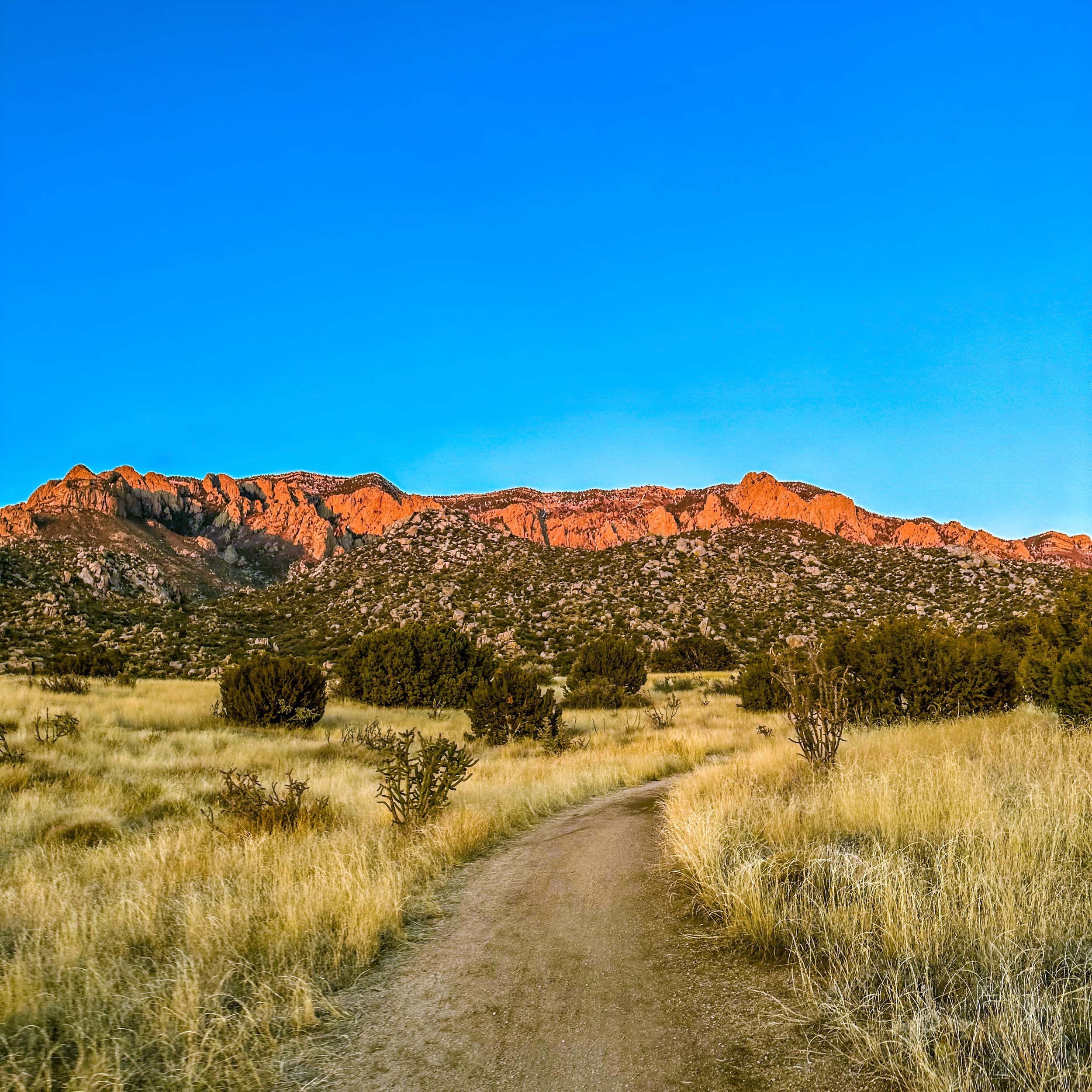
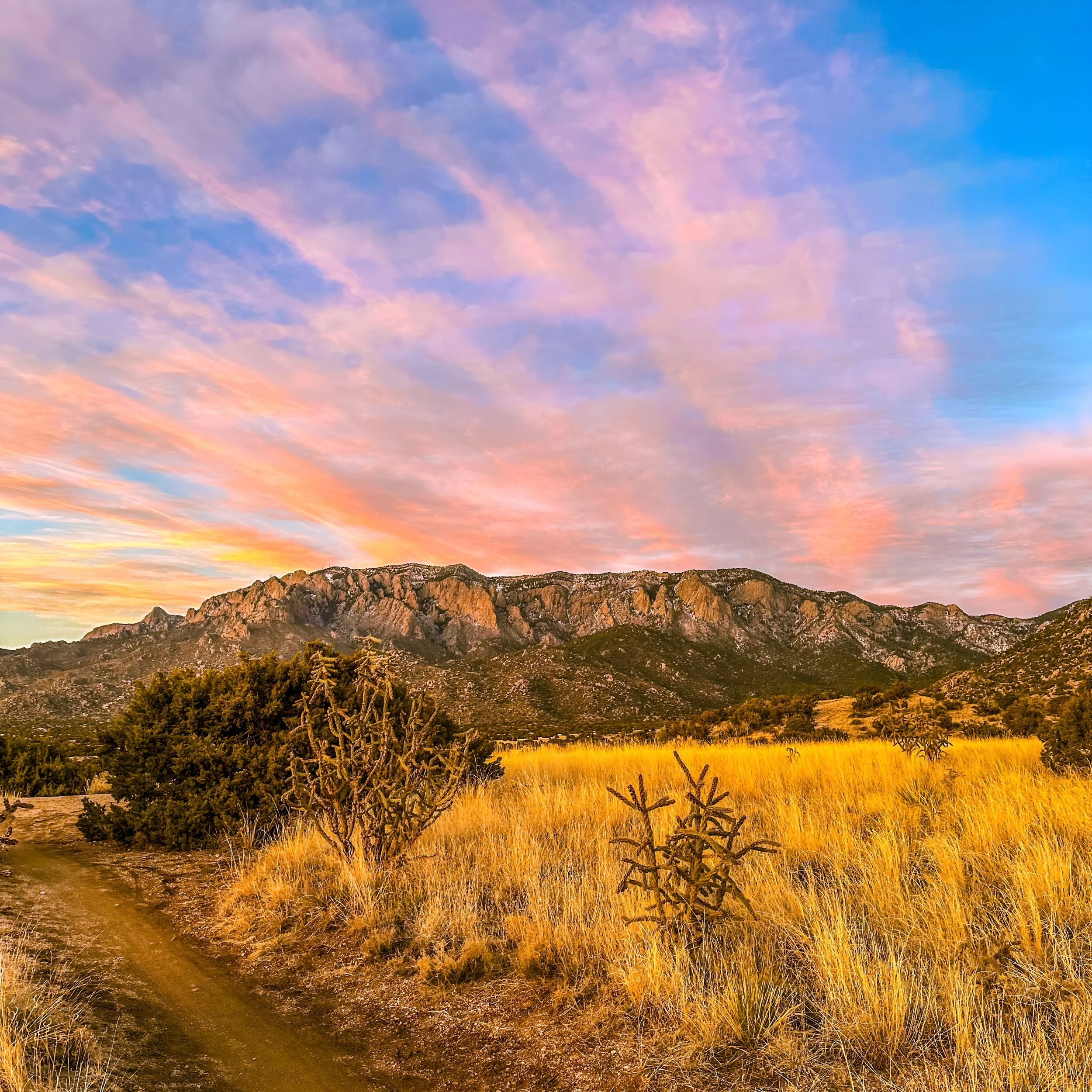
Sandia Mountains
The spectacular Sandia Mountains and their foothills are the go-to spot when the run calls for some elevation and spectacular 360° views! The trails are a combination of developed dirt trails, single tracks, and an occasional stretch on a dirt service road. The City of Albuquerque Sandia Foothills Open Space contains approximately 2,650 acres of rolling hills with tons of awesome trails right at the base of the Sandia Mountains. Immediately surrounding the open space is the Cibola National Forest with many trails that take you through about 37,000 acres of jaw dropping mountain scenery. Abundant high desert flora include a variety of grasses, chamisa, beautiful wildflowers, cane cholla, and prickly pear cactus. Single-seed juniper and New Mexico piñon trees dot the landscape. Experience multiple climate zones the higher you climb. Elevation ranges from 5,700 to over 10,000 feet with the pine forests starting at 7,500 feet, mixed-conifer forests starting at 8,000 feet, and spruce-fir forests starting at 9,800 feet. Always stay on the trails because they are well marked and developed making it hard to actually get lost (you may get turned around but you’ll always connect to another trail).
-
We recommend parking at the Elena Gallegos Open Space lot. It costs $1 during the week, and $2 on the weekends (cash only). You can either pay the Park Ranger or use one of the envelopes when a ranger is not present - make sure that if you use an envelope to put the tearaway tag on your dash or you may receive a citation.
-
There are restroom facilities at this location. They are located at the top of the Elena Gallegos parking lot by the Pino Trail Head (trail 140). Please note they do not have running water.
-
It’s easy to get turned around the first couple of times but its actually hard to get lost because the trails are all well marked and defined. If you find yourself in a pinch, find 365 and take that. Almost every trail connects to it at some point and spans the length of the foothills. It is also the closest to civilization.
Don’t go off-trail. This is the wilderness and gets really rough off-trail. Things can go sideways quickly including getting lost and/or wildlife encounters.
Ask the Park Ranger for a complimentary map. It’s a handy thing to look over prior to your run and a neat thing for after. Here is a link to a handy digital map of the parking area and trail heads in the meantime.
Trail shoes with rock plates are highly recommended as there are rocky sections that you’ll likely encounter. There may be some sandy sections and slippery downhills (the lugs will be helpful).
-
Coming Soon!
-
For more information about the Sandia Foothills, please click here for the City of Albuquerque Elena Gallegos Open Space Guide.
Sandias North (Placitas)
About 10 minutes north of Albuquerque are the Placitas trails on the northern side of the Sandia Mountains. The terrain is similar, yet quite different from the Sandia Foothills trails which are on the western side. Placitas offers spectacular views of the southern Rocky Mountains which are just north of the Sandias. There is a Cibola National Forest parking lot where you can park for free. Follow the forest road for miles where you can run gentle soft surface with some rolling elevation for many miles. You can also try out the more challenging single track trails off of the forest road where you’ll get vistas that give you a whole different perspective of Albuquerque and the surrounding area. You’ll also get some nice elevation gain and a technicality into the mix. My personal sweet spot is a mix of forest road and trail. As with the Sandia Foothills trails, you’ll see similar high desert flora and the higher you go, a range of climate zones. Elevation ranges from 5,700 to 10,600 feet in this area with the pine forests starting at 7,500 feet, mixed-conifer forests starting at 8,000 feet, and spruce-fir forests starting at 9,800 feet.

-
Parking here is easy. We recommend parking at the second parking lot (just up from the first one you’ll see). The overall trail access is better.
-
There are no restroom facilities at this location.
-
Take hydration because there are no hydration sources in this area.
It’s easy to get turned around the first couple of times but its actually hard to get lost because the trails are all well marked and defined. If you find yourself in a pinch, find your way back to the main road which can be seen from many vantage points
Don’t go off-trail. This is the wilderness and gets really rough off-trail. Things can go sideways quickly including getting lost and/or wildlife encounters.
Trail shoes with rock plates are highly recommended as there are rocky sections that you’ll likely encounter. There may be some sandy sections and slippery downhills (the lugs will be helpful).
-
Coming Soon!
-
Tramway Trail
The Tramway Trail runs parallel to the Sandia Mountains on one side and Tramway Boulevard on the other and is about 6,100 feet in elevation. This is your ticket when you want mileage that’s relatively flat, paved, and about 1,000 feet higher in elevation than the Rio Grande Bosque. It’s also your ticket if you want to run close to the mountains but don’t like trail running. This two lane trail is separated from the roadway by plenty of natural high desert flora It is well maintained with Sandia Mountain views, City of Albuquerque views, and glimpses of The Albuquerque Volcanos the entire way. Please note that the trail does have intersections with residential roads so please use caution when approaching them. Lots of bikes use the path but you’ll see the more hardcore riders using the designated bike lanes on Tramway Boulevard which means that trail traffic is not an issue.

-
There are several places to park along this trail but we recommend the following…
The Michael Emery Bear Canyon Trailhead on Spain Road.
The Embudo Trailhead at east end of Indian School Road.
County Line Restaurant/Bar at the junction of Tramway Boulevard and Tramway Road. You can grab a cold beer and some food after if you’d like!
Boxing Bear Brewing at the Bridges on Tramway Shopping Center. You can enjoy a cold beverage after!
-
There are no facilities on this trail. There are stores along the way including a large Smith’s grocery should you need the restroom and/or hydration.
-
This trail does not have any shade cover so we advise taking advantage of the morning hours if possible on hot days.
If you prefer evenings, this is a fantastic way to experience New Mexico sunsets.
It’s virtually impossible to get lost on this one.
-
Coming Soon!
-
Coming Soon!
Albuquerque Volcanos
This is one of the coolest places to run and totally worth checking out! Sitting atop Albuquerque’s West Mesa, this loop takes you through the Volcanos Section of Petroglyph National Monument and The City of Albuquerque Open Space. The rural desert landscape is filled with pockets of black volcanic rock which gives it a feeling of being a different planet. The Three Sisters Volcanos jut out of the landscape, thriving urban civilization can be seen off in the distance, and there are mountain views in every direction.
My favorite route (10ish miles) starts at the main trail head where you’ll head towards the first volcano and quickly hang a right an old dirt road that takes you south, away from the main developed trail area and off into the vast open space wilderness. The road initially has a gentle drop and there are amazing views of the desert, volcanos, the Sandia and Manzano Mountains, as well as the City of Albuquerque and the Rio Grande Valley. The road gradually starts to loop in a northern direction with even more desert vastness and beautiful views of the Sandias and of the Rockies off in the distance. Look left and you will continuously see The Three Sisters. Please note that depending on your vantage point, one or two may disappear on periodically. Equally cool is the dramatic volcanic drop off wall from Albuquerque's West Mesa down to the Valley. Keep on going until you pass through an open gateway and take the single track trail that veers off to left alongside the old fence line. Off in the distance, massive wooden power lines will come in to view and you’ll keep on running until you arrive at the lines. From there, take the old dirt power line service road up the hill. There will be a couple of other volcanos in sight during this segment because the power lines go in their direction (northwest). As you climb, be on the lookout for a single track crossing. It’s not totally obscure but not super obvious either. At the crossing, you can keep on the service road, take a single track straight, or take a single track that veers slightly left. You’ll take the latter trail which takes you up another hill and back towards The Three Sisters. The single track intersects with an old narrow dirt road that becomes part of the main trail system. You’ll climb up this road which becomes main trail to the middle volcano and then take the short but steep and very rocky trail to the top. Soak in the truly magnificent 360 views of the entire region. Once you’re done, you will have to descend the way you came up. Go left on the main trail and take the next left - it’s marked and part of the main trail system. This dirt road/trail will take you back to the parking area. You can always tack on more miles by running around the main trails or even run a reverse loop!

-
Parking at the Volcanos section of Petroglyph National Monument is easy. There is decent size lot that is at the trailhead. Please pay attention to the time if you are there later in the day because the National Park Service will close the gate. Please note there is an overflow parking area just outside the gated lot where you can park at any time.
-
There are restroom facilities at this location (at the trailhead). Please note they do not have running water.
-
This trail does not have any shade cover so we advise taking advantage of the morning hours if possible on hot days.
Please note this route is incredible but also challenging. While it’s not too strenuous physically or crazy technical, it is in the middle of the desert, not the most well defined, and you’re likely gonna be the only one out there. We highly recommend that you have a good amount of trail experience and a good sense of direction.
There are the main trails around the volcanos that are developed and very runnable for all levels - this loop is about 4 miles.
Trail shoes with rock plates are highly recommended as there are several very rocky sections and the volcanic rock can be sharp (there are some sandy sections where lugs help too).
If you decide to step off trail for better views, please be on the lookout for rattle snakes - they are out there - luckily there isn’t much vegetation so they are much easier to spot.
-
Coming Soon!
-
Los Poblanos
The Los Poblanos Open Space is one of our favorites because you get to see the agricultural side of Albuquerque including the historic acequia systems which have been the lifeblood of New Mexico for centuries and continue to be through present.
My favorite route starts at the Los Poblanos Open Space parking lot, you’ll start out on the dirt farm roads which are part of the space. As you tour the fields, you’ll soon come up on the acequia systems and will run alongside them on their dirt service roads and then loop back towards the fields when you reach Rio Grande Boulevard. Please note that there is one very lightly traveled residential road that you’ll have to cross twice while on the acequia service road loop. This road is located on the section between the farmland and Rio Grande Boulevard so while highly unlikely, you may encounter a motor vehicle. The surface is all dirt ranging from hard pack road to soft/sandy depending on where you are at. On some portions of the run, you’ll get spectacular views of the Sandia Mountains to the east and The Albuquerque Volcanos to the west - all from a Rio Grande Valley perspective which is pretty cool.

-
Parking here is easy and there is plenty of it!
-
There are restroom facilities at this location. They do not have running water.
-
It’s easy to get turned around the first couple of times but its actually hard to get lost because the trails are all well marked and defined. If you find yourself in a pinch, find 365 and take that. Almost every trail connects to it at some point and spans the length of the foothills. It is also the closest to civilization.
Don’t go off-trail. This is the wilderness and gets really rough off-trail. Things can go sideways quickly including getting lost and/or wildlife encounters.
Trail shoes with rock plates are highly recommended as there are rocky sections that you’ll likely encounter. There may be some sandy sections and slippery downhills (the lugs will be helpful).
-
Coming Soon!
-
More Trails Coming Soon
Coming in the very near future will be trails such as the Albuquerque Academy Loop, the famous La Luz Trail as well as a bunch more cool stuff from amazing parts of New Mexico. You can sign up to be notified of major updates if you’d like. We promise we will only send legit news, no spam, and never share your info.